


Photo by Joe Hodgson
This is Colorado, where men and women are judged by how many 14ers they’ve hiked and how dirty their Subarus are. Never fear, read on to up your Colorado cred.
Coloradans wouldn’t be Coloradans without monster hiking calves, an excessive number of backpacks and a go-to anecdote about mountain climbing. Whether you’re looking for a leisurely stroll, a starlit overnight trek or a breathtaking ascent, Colorado has it all, and it’s in your backyard.
Considerations: Remember to check with park authorities for seasonal closures and required permits. Always start mountain ascents early enough to be back below the alpine line by noon, and hike through the week for smaller crowds. The north face of any mountain will be hardest and most dangerous. Practice Leave No Trace standards on any trip, and always take more food and water than you think you’ll need, especially on trips of four or more hours (don’t forget a collapsible dog bowl for Fido, either). Distances reported here are one-way unless marked as roundtrip/loop.
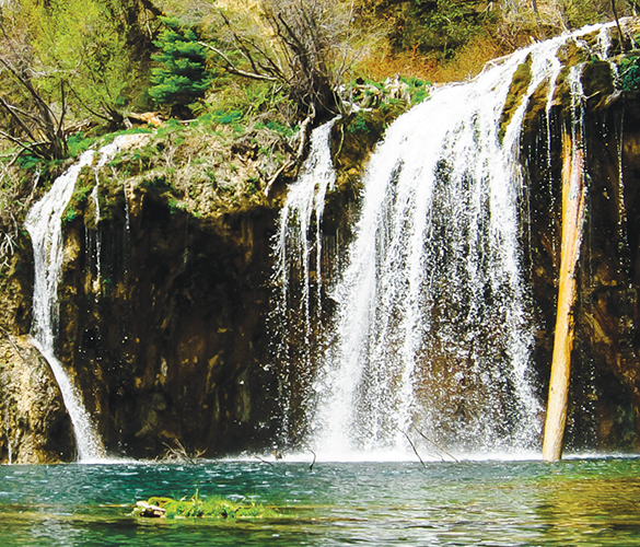
Photo by Joe Hodgson
Day Hikes
Mount Sanitas and Centennial Park
From the Centennial Trailhead, the easy, mile-long Sanitas Valley Trail connects to the moderate 2.2-mile Dakota Ridge Trail to the east (good for trail running) and the moderate 3- to 3.5-mile Mount Sanitas West Ridge Trail that loops to the more than 6,850-foot-high summit of Mount Sanitas (beware of deceptive false top outs here). The Dakota Ridge Trail is a hogback trail that offers views of Denver on one side and Red Rocks amphitheater to the west. The steep, difficult mile-long East Ridge Trail connects the Sanitas Valley Trail to the Mount Sanitas Trail. The 2.8-mile Red Rocks Trail (best accessed from the Settlers’ Park Trailhead) is a moderate to difficult, bike-friendly trail that connects to Dakota Ridge to make a great six-mile loop. Confused? This series of interconnected trails are clearly marked from every trailhead, focus on the view and take a nice, long walk.
Regs: Dogs are allowed, but voice and sight control standards apply. No bikes on the Sanitas loop, but they are allowed at Red Rocks and Dakota Ridge.
Directions: In Boulder travel about a half of a mile west of 4th Street on Mapleton Avenue and park at Centennial Trailhead on the south side of Mapleton. Overflow parking is up Mapleton in Sunshine Canyon on the left.
Chautauqua Park/Flatirons
Although pretty much everything here is easy to moderate, the Mesa and McClintock trails are the best for pretty, green strolls. They’re about six miles each. The First-Second Flatiron Trail (about a mile each way) is an easy hike, accessed via the Chautauqua trail to the Bluebell/Baird trail split. Turn left and follow the sign for the Flatirons Trail. Less than .1 miles later, the Flatirons Trial splits. The Royal Arch Trail, which narrows into the Flatiron Loop Trail (about a mile and a half each way) is a nice moderate hike, but it has rock stairs, so it’s not for anyone with cardio or knee problems. At its end, turn left to the Bluebell/Baird trail back to Chautauqua, or turn right and follow Mesa trail to the Ranger Station (an easy 2.5-mile loop). The Gregory Canyon trail (about a mile each way, with a steep elevation gain) is slightly more difficult and a great butt workout.
Regs: Dogs are allowed, but voice and sight control standards apply. Cyclists will be ticketed.
Directions: In Boulder, Broadway and Baseline roads both lead to the Chautauqua Park entrance on the left.
Heil Valley Ranch
Heil Valley’s easiest hike is 1.3-mile Lichen loop, for hikers only (no bikes or horses). Picture Rock (5.5 mi), Wild Turkey (3 mi), and Wapiti (2.5 mi) trails, and Ponderosa Loop (2.6 mi) are all moderate hikes. Wapiti provides access to all Heil Valley trails, except Lichen Loop. At its peak are Ponderosa and Wild Turkey loops, as well as the Picture Rock trail north from the Wild Turkey Trail to Hall Ranch, Lyons. Hall Ranch is a haven for cyclists, with 10-miles of trail containing a 2.2-mile stretch called Nelson Loop, which starts at Bitterbrush Trailhead and runs up the south side of Indian Lookout Mountain. The easier approach is from Antelope Trailhead, if there is parking. Avoid weekends at Hall Ranch because the cyclists crowd out the main loop, but through the week, looped hiking trails off of Nelson offer views of Longs Peak.
Regs: No dogs. Cyclists and equestrians welcome everywhere but Lichen Loop.
Directions: Follow Hwy. 36 north of Boulder and turn left (west) onto Lefthand Canyon Drive. Half a mile down, take a right at the Heil Valley Ranch sign on Geer Canyon Drive. It’s a dirt road for about a mile and a half (go slow and watch for cows and wildlife).
Great Sand Dunes National Park
Great Sand Dunes features the tallest sand dune in North America as well as the beautiful Sangre de Cristo and San Juan mountain ranges. For a uniquely challenging but not horribly long hike, park near Medano Creek and summit Star Dune from High Dune, hiking a mile to a mile and a half depending on your route, or go straight up Star Dune, hiking 3.5 to four miles to the top. Camping is allowed throughout the park and preserve backcountry, but not in the dunefield outside of the day-use area. Nearby Buck Creek, north of loop two in the campground, offers a short hike into the backcountry for a break from the dunes.
Regs: Leashed dogs are welcome on the main trails, not in the backcountry, but watch for paw blisters in the hot summer months.
Directions: Travel 35 miles northeast of Alamosa from U.S. Highway 160 and CO 150 from the south, or from State Highway 17 and County Lane 6 from the west.
Hanging Lake
The trailhead is marked near the parking lot and promises about an hour hike. Stick with it for a mile and a half (a cliff-side set of stone steps) and a sparkling turquoise lake and splaying waterfall is tucked into Glenwood Canyon. It’s great for a nice rest and a picnic. It’s free to get in, and Hanging Lake is the perfect place to photograph Colorado in all of its glory. Don’t accidentally turn at Deadhorse Trail, which does not lead to the lake. On the way back, a sign marks the turn off to a short walk to Spouting Rock. This fall is secluded, a fantastic fairytail tucked away on the hike.
Regs: No dogs or fishing. Stairs and steep rocks take this trail off cyclists’ options list.
Directions: I-70 westbound bypasses Hanging Lake entirely, so westbound travelers should exit at Grizzly Creek rest area and turn left onto the eastbound ramp. Once traveling eastbound, pass Shoshone and take the exit marked Hanging Lake. Signs mark the rest area and trailhead.
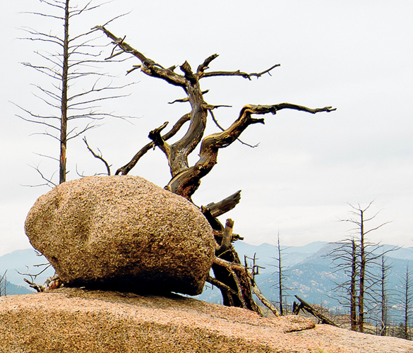
Photo by Joe Hodgson
Overnight/Backpacking
Baker Pass
For a lumbering backpacking trek, head west on the gravel road from the Bowen/Baker Trailhead to the marked trails for Bowen Gulch and Baker Gulch (the first landmark, about a half a mile in)—the next isn’t until 3.2 more miles west down Baker Gulch, at the junction of Parika Lake (roughly 5.5 miles from the trailhead) and Baker Gulch trail. Camp at Parika Lake (about seven miles from the trailhead) or turn right (north) toward Baker Pass and the Continental Divide. Cairns (man-made rock piles) mark the sketchy trail near the pass, which leads to a remote part of the Never Summer Mountains. Rocky Mountain National Park doesn’t manage the backcountry camping—it’s mostly National Forest land—so call 970.887.4100 for specifics. Most travelers camp and fish at Parika Lake, then continue southwest along the Continental Divide ridge (left at the T) and into Bowen Pass the next morning. Bowen Lake offers more camping down the Bowen Lake Trail off of the Continental Divide Trail. All in all, the trip runs 14-16 miles, depending on trails and gorgeously distracting diversions. Schedule the Continental Divide portion before the 2pm storms.
Regs: Dogs are allowed off leash after the first mile or so of the trail (after the land becomes National Forest instead of Rocky Mountain National Park land). RMNP restrictions to overnight parking and an entrance fee apply.
Directions: Follow Highway 34/Trail Ridge Road 6.7 miles north of the Kawuneeche Visitor Center or 10.6 miles south of Milner Pass to the Bowen/Baker Trailhead on the west side of the highway. The turnoff from Trail Ridge Road/Highway 34 says National Forest access, Bowen and Baker Gulch.
The Colorado Trail
Although it takes one or two months to backpack the entire 483-mile Colorado Trail, it is also broken up into 28 manageable hikes (generally moderate) that range from roughly 11 to 33 miles, or sponsored hikes with the annual Colorado Trail Trekking Program. The CTTP hikes allow travelers to carry only a daypack, with overnight gear shuttled to the next camp daily—all of the way from Denver to Durango. Hike early in the morning to avoid unpredictable, high-altitude weather, and plan for all conditions with seasons in mind. Nearby highlights: Segment five from Long Gulch to Kenosha Pass offers a moderate 15-mile hike through the Pike and San Isabel national forests. Segment six offers a harder, 33-mile option from Kenosha Pass to Goldhill Trailhead through the Pike, San Isabel and White River national forests. Both segments offer camping throughout. See it all at coloradotrail.org/segments.html.
Regs: The trails are dog friendly, but check area leash/off-trail laws because they may change from park to park. Camping is dispersed throughout the areas.
Directions: Long Gulch Trailhead lays along Lost Park Road/Forest Road 56 seven miles southwest of Grant. Drive west from Grant on Highway 285 to reach the campground. Kenosha Pass is just off of 285, four miles north of Jefferson.
Medano Lake and Mount Herard
Medano Pass’ gorgeous, primitive road campsites are breathtaking in summer and fall. But trail access is limited—especially in winter and spring—and hunters use the area, so be cautious, prepared and wear bright colors. Off-trail camping is allowed most everywhere in the preserve. The approach trail to Medano Lake, which is surrounded by campsites, is about a half mile west of Medano Pass on Sand Ramp TH (for high-clearance 4WDs only). The lake is about four miles from the trailhead. In the park along the Sand Ramp Trail, Aspen Campground (in an Aspen grove) is almost six miles from the Point of No Return and about 2.3 miles from the sand ramp. It’s the highest designated backcountry site in the park, with views of the dunefield. Sand Creek campground is about 10.5 miles from the Point of No Return in a grove of cottonwood trees, and it’s the only backcountry site that allows campfires (with wood found locally on the ground). For a moderate 13er, Climb Mount Herard with views of the Crestone Group mountains and Great Sand Dunes National Park.
Regs: No dogs outside of the day-use area. Check with Great Sand Dunes National Park for closings and conditions. The park’s Visitor’s Center offers free backpacking permits and information.
Directions: Access the Medano Lake trailhead from the west via Great Sand Dunes National Park (travel 35 miles northeast of Alamosa from U.S. Hwy. 160 and Hwy. 150 from the south, or from State Hwy. 17 and County Lane 6 from the west to get to
the park).
Flat Tops Wilderness
Colorado’s second largest wilderness with more than 160 miles of trails was nature-made for polyamorous hikers. Lakes, streams, elk, moose, beetle-stricken spruce and fir, and massive burned patches offer travelers a buffet of striking visuals outside of Colorado’s beautiful mountains and hills. Here are the highlights: great views from the 11,600-foot Devil’s Causeway (start at the East Fork Trail beginning at Stillwater Reservoir near Yampa), Mandall Pass (at the top of the Mandall Pass Trail which begins at Yampa Reservoir), Turret Creek (via Turret Creek trail at the Hilltop Trailhead near Sweetwater Lake, ends at Trapper’s Lake Trail 1816), and the 11,070-foot, lava capped White River Plateau (via Turret Creek Trail). Instead of a structured hike, take a weekend, plenty of supplies and just explore.
Regs: Dogs are allowed, but voice and sight control standards apply. Both national forests offer regulated campsites as well as plenty of backcountry camping throughout Flat Tops. Check with the Yampa Ranger District (970.638.4516) for seasonal closings and conditions.
Directions: Trails throughout the Routt and White River National Forests about halfway between I-70 and Steamboat Springs. Flat Tops Trail Scenic Byway goes from Meeker to Yampa on the edge of the wilderness. Nearby towns include Meeker, Yampa, Steamboat Springs, Glenwood Springs, Buford, Toponas, Burns, New Castle, Craig, Hayden, Phippsburg and Oak Creek.
Arapaho/Caribou passes
The Arapaho Pass Trail runs up the north slope of the North Fork, Middle Boulder Creek drainage and into Indian Peaks Wilderness. Ignoring the turnoff to the Diamond Lake Trail, travel a couple of miles to the Fourth of July Mine and turn right (northeast) onto Arapaho Glacier Trail 905 up to the Arapaho Glacier Overlook, about 3.5 miles from the trailhead. From there, travel down to Rainbow Lakes Campground to settle in for the night, or Arapaho Pass Trail goes west to Arapaho Pass, which is about three miles from the trailhead. When Arapaho Pass Trail intersects with Caribou Trail 11, it turns off to Lake Dorothy, which is roughly 3.5 miles from the trailhead. Caribou Trail is basically an old road blasted into the side of a cliff, and it’s sliding away in places. The trail runs out at Caribou pass, but a trail runs down the far side for about four miles to Junko Lake Trailhead. From Lake Dorothy, the north slope to Caribou Pass runs to Caribou Lake on the Arapaho Pass Trail. Snow drifts give Caribou Pass a short, so check conditions. Weather can get nasty above the treeline, so start early.
Regs: Leashed dogs allowed. Backcountry camping permits from Indian Peaks Wilderness are required to camp in the designated backcountry zones. Camping is prohibited within 100 feet of lakes, streams and trails. Campfires are prohibited east of the Continental Divide and at Caribou Lake. Call the Boulder Ranger District (303.541.2500) for seasonal specifics.
Directions: From Nederland, follow County Road 130 to Eldora (the ski resort signs point the way). Continue straight through Eldora past the pavement’s end. Follow the fork right to the Fourth of July Trailhead, ignoring Hessie Trailhead parking.

14ers
Longs Peak
The only 14er in Rocky Mountain National Park, Longs Peak’s Keyhole route is a 15-mile, moderately difficult 14,255-foot ascent. Longs is more of a scramble than an easy hike, even in the summer when it’s not snowy. It doesn’t require ropes and harnesses, but the terrain is rough, it’s a little steep, somewhat exposed and can have snow. This isn’t one for the younger kiddos (more than 50 people have died climbing this mountain), but it’s a rewarding summit for strong hikers. Climb during the week to avoid crowds, and in the summer to avoid dangerous snow and ice. Bring crampons and an ice pick for technical climbing when snow and ice are present.
Regs: No Dogs. RMNP camping at Longs Peak is permit free, but camping in the back country and boulder field requires a permit. No permit required to climb.
Directions: Longs is 12 miles southwest of Estes Park in Rocky Mountain National Park, near Estes and Meeker parks. For the north face, drive roughly nine miles south from the intersection of US 36 and CO 7 to the turnoff for the Longs Peak Ranger Station. The southern approach is north 10.5 miles from the junction of CO 7 and CO 72 on the Peak to Peak Highway to the Longs Peak Ranger Station turnoff. From the turnoff, drive west one mile to the trailhead.
Torreys & Grays peaks
At 14,267 and 14,270 feet, respectively, Torrey’s and Gray’s peaks come in a set—summit one and you can easily summit them both in the same day. It’s about an 8.5-mile round-trip hike to summit them both. The super stable hike to the summit of Gray’s, and a slightly more difficult/less stable hike to Torrey’s summit can end in a snow slide to the bottom if the weather’s right. If no snow is protecting the mountainside, stay on the trails here. It’s rude to detract from the view and disturb what little of nature is left on these mountains by trampling it. Besides, nobody likes a cheater.
Regs: Dogs allowed. Celebrate the double send at several free camping spots throughout Stevens Gulch. No permits required.
Directions: Travel four miles north of I-70 on the Continental Divide in the Front Range to Stevens Gulch Trailhead. Anyone in Bakerville, Montezuma and Keystone can point the way to these peaks in the Arapaho National Forest. Four-wheel-drives are the best way to access the roads up here, but 2WDs can take it in nice weather. Travel via Forest Road 189 in Stevens Gulch from the northeast (take exit 221 from I-70).
Mount Elbert
Mount Elbert is the Rockies’ highest peak at 14,433 feet, and it’s the second tallest in the contiguous United States (California’s Mount Whitney beats it out by about 65 feet). The South Mount Elbert Trail from the lower trailhead to the summit is about 11 miles roundtrip with a 4,850-foot elevation gain; from the upper trailhead, it’s about 7.5 miles roundtrip and a 4,000-foot elevation gain. The north face hike on the North Mount Elbert Trail is technically easy as well and only about nine miles roundtrip with about a 4,500-foot gain.
Regs: Camping near north trailhead. This is the highest spot in the United States that allows dogs. Leashes required. No permit required to climb or hike.
Directions: To hike the north trail, head south from Leadville on U.S. 24 and turn right on CO 300. Take a left on County Road 11 and right at Halfmoon Campground after about a mile. Five or so miles later, the trailhead is on the left. From the north and west, 4WD access goes to 11,000 feet on Halfmoon Creek Road. It’s in the San Isabel National Forest.
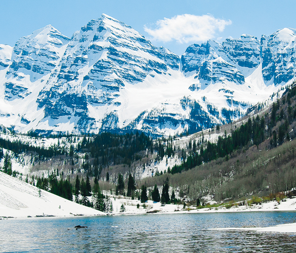
Maroon Peak
(South) Maroon Peak and North Maroon Peak aren’t for the kids, dogs or grandma, but the family will appreciate pictures of the surrounding Maroon Bells’ pyramid-like mountains. These are climbs, not just hikes, especially North Maroon Peak, so rookies should train before trying to knock Maroon Bells out. Both ascents start at the Maroon Lake Trailhead. Cairns mark the most commonly used routes, but only experienced mountaineers should lead the way. Although the North Maroon Peak route is nine miles compared to Maroon Peak’s 12, the North Maroon Peak requires rope and helmets (especially in snow and ice). Maroon Peak can be topped out without the gear. North Maroon Peak is less than a half mile north of Maroon Peak. Falls from either exposed climb can be fatal. Because these routes are considerably harder than most we’ve mentioned, the crowds here are smaller.
Regs: Camping along Maroon Creek Road. Leashed dogs allowed. Obtain free permit tags at the trailhead. Shuttle fees apply from Ruby Park in downtown Aspen when the road to the trailhead is closed.
Directions: Maroon Creek Road offers 2WD paved access to 9,600 feet from the north out of Aspen, but the road closes to traffic seasonally, so the bus charges a small fee for people and none for dogs. Nearby towns include Aspen and Snowmass.
Mount Bierdstadt
This baby 14er is great for beginners, said Dr. Kelli Space at Jasper Animal Clinic, whose dachsund has summitted a few peaks with her. It’s about seven miles up, with trail almost the entire way. Although this isn’t hiking on a dirt road on level ground, Bierdstadt is pretty darn easy. This may include a few loose rocks (talus/scree) or maybe a little bit of snow, depending on the season, so great-grandma may have a little bit of trouble rocking this one, but everyone else should make it to the top comfortably.
Regs: The campground below the trailhead on the Guanella Pass road is the easiest opportunity to celebrate the summit. Dispersed camping is also available in Scott Gomer Creek. Leashed dogs allowed. Free permit available at trailhead.
Directions: Bierstadt is two miles west of Mount Evans, in the Mount Evans Wilderness. From the north, take Guanella Pass from Georgetown, down I-70; or from the south, take 285 from CO 5, which snakes to the top of Mount Evans. It’s near Georgetown, Idaho Springs and Grant in Pike and Arapaho national forests.
Also, check out this year’s must-have gear!


As the owner of the magazine (who has also decided to launch a second publication this year) getting days off are rare. So while I have to work most of this 3 day weekend, the family and I decided to take one day and enjoy this beautiful area that we live in. I used my HOT issue for both a great hike and some yummy Fro-Yo!
We spent Saturday hiking Mt Sanitas, which turned out to be a great day for enjoying Boulder. Surprisingly, the mountain was not to crowded. Maybe Boulderites headed up to the big Rockies over the weekend?
One thing we thought curious on our hike, was the number of dog poo bags laying on the side of the trail. The rules at the base of the hike state that these bags need to be hauled out, yet there were numerous bags laying all along the trail.
We questioned the environmental impact of this. Would it have not been better to jave just left the dog poo in the dirt than to have wrapped it up in a bag, only to leave the bag on the side of the mountain?
Our conclusion? Leave no mark, Pack your trash all means dog poo too!