


 In Nevada’s monstrous Lake Mead Reservoir, the term “dead pool” has a dual meaning. For hydrologists, dead pool represents a catastrophically low water level in a reservoir below which the water can no longer pass through the outlet works of the dam or produce electricity. Dead pool in Lake Mead might also relate to the hundreds of human bodies concealed within its depths, some of them Las Vegas mob hits, most of them unrecovered drowning victims. In recent years Lake Mead’s water level has plummeted alarmingly towards dead pool and, as it does so, has exposed human remains along new shorelines.
Lake Mead currently sports a giant white “bathtub” ring indicating the newly exposed land. When the lake reached its lowest level in 2022, the ring was nearly 200 vertical feet, and the reservoir held only 30% of its capacity. Apocalyptic predictions of the reservoir’s doom flooded the national media. Should Lake Mead reach dead pool, tens of millions of Americans would lose power, water faucets would run dry in many cities, and hundreds of thousands of acres of some of America’s most important agricultural land would dry up.
The water level has since risen about 30 feet because of a lucky break. The southern Rockies had an epic snow year in 2023 and unleashed a monster runoff which helped replenish the Colorado River Basin including Lake Mead. But one very good snow year cannot reverse a multi-decade megadrought, and demand for Colorado River water continues to grow year by year. It’s been decades since the river flowed regularly into the ocean. All of its water is now used up before it gets to the sea. In northern Mexico, south of the Arizona border, what used to be a vast wetland delta full of wildlife has turned into a dusty wasteland. Demand for the river system’s water continues to grow while the megadrought in the Southwest marches on in the near future harbors a potential water catastrophe.
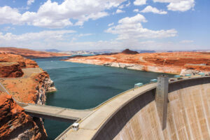
Glen Canyon Dam, Arizona, USA. The Colorado river behind the dam, surrounding by red rocks, desert, and mountain.
A river by any other name
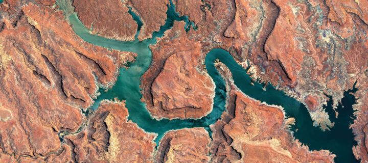
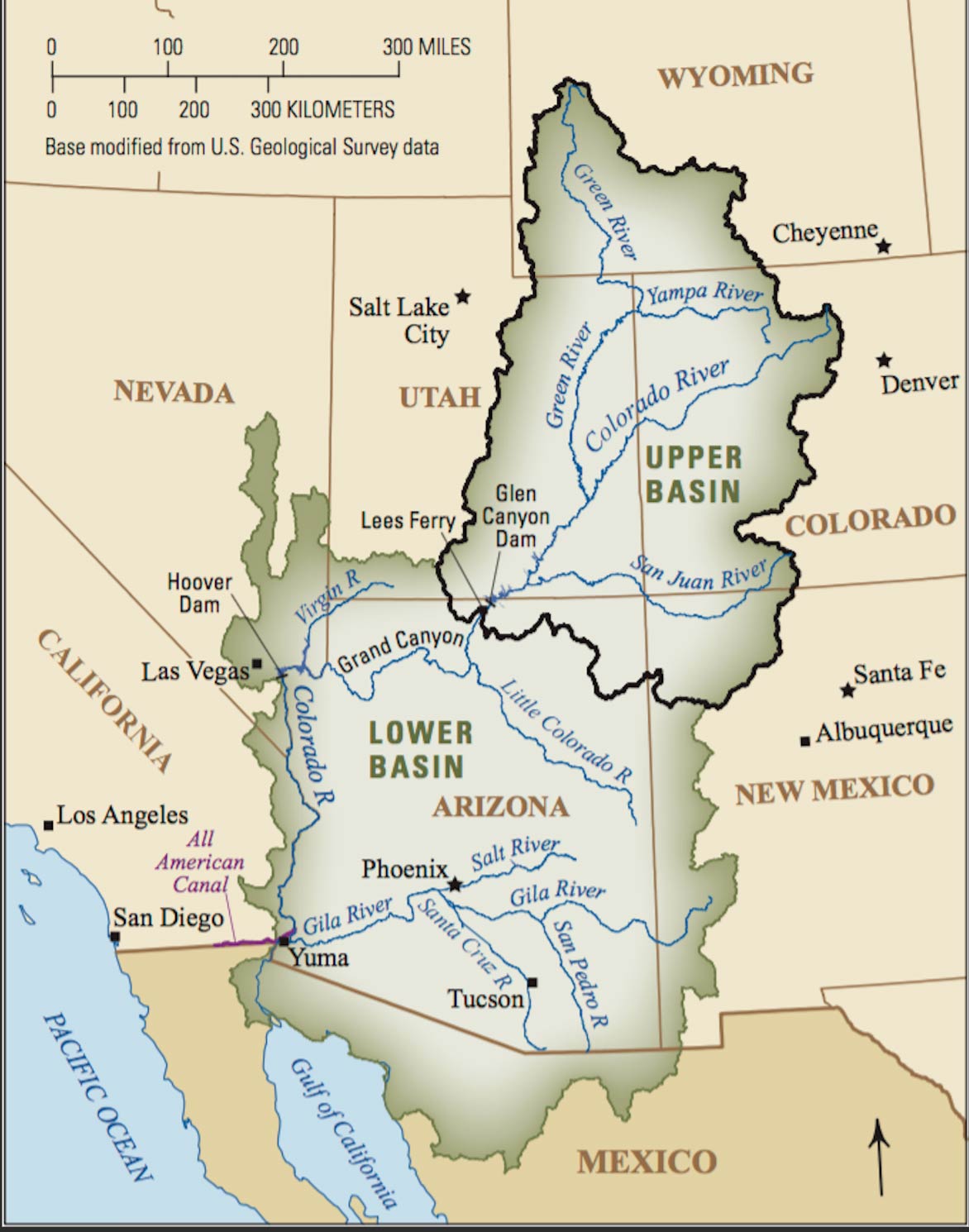
The official source of any river is mostly an arbitrary designation based on the happenstance of geographic naming. Both the Colorado and Mississippi Rivers, for example, have official sources that make little logical sense. A river, if viewed from above, resembles a giant leafless tree with ever smaller branches extending in all directions throughout the river’s basin in a fractal pattern. A river like the Colorado does not have a single source; rather it has hundreds of thousands of them throughout its vast drainage basin spread out over thousands of miles.
However, if we were to consider a river’s most logical single source to be the point on the river system that is the farthest from its mouth in river miles, then the source of the Colorado River is in west-central Wyoming where the Green River begins, not in the Colorado Mountains. The Green and Colorado Rivers merge in the middle of Canyonlands National Park in Utah. Upstream from there, the Green is more than twice as long as the upper Colorado River branch. Had the entire river been named the Green — which it almost was — then its official source would most certainly be in Wyoming, not Colorado. Similarly, the source of the Mississippi should be the headwaters of the Missouri River in Montana instead of its officially recognized source in Minnesota, which is hundreds of river miles closer to the Gulf of Mexico than it is the start of the Missouri.
Where does the water come from?
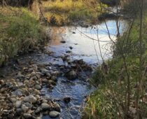
 Some of the water that fills Lake Mead starts as snowmelt high up in the Never Summer Mountain Range near Rocky Mountain National Park in Colorado. Even up there where the Colorado River system is nothing more than a series of tiny mountain creeks, we begin to consume its waters. The first users of the Colorado’s water are you, me, and the rest of our neighbors here in the cities of the Front Range.
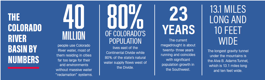
Unless you are on a well system, when you turn on your water faucet you are probably consuming water that was brought to you through a tunnel under the Continental Divide from the headwaters of the Colorado River. There are eight such water diversions from the Western Slope to the Front Range, the biggest of which is the Big Thompson Project. There is also the Grand Ditch, the Moffat Tunnel, the Roberts Tunnel, the Continental Hoosier System, the Homestake Project, the Twin Lakes Tunnel, and the Fry-Ark Project which provides water for Colorado Springs. Collectively they transfer almost a half million acre-feet of water annually from the Western Slope to the Front Range, all from the Colorado River’s headwater streams including the Eagle, Fryingpan, Roaring Fork, Blue, and Fraser Rivers.
The longest of these tunnels is the Alva B. Adams at 13.1 miles long and 10 feet wide, part of the Big Thompson Project. It passes right under the middle of Rocky Mountain National Park and emerges near the aptly named East Portal Campground.
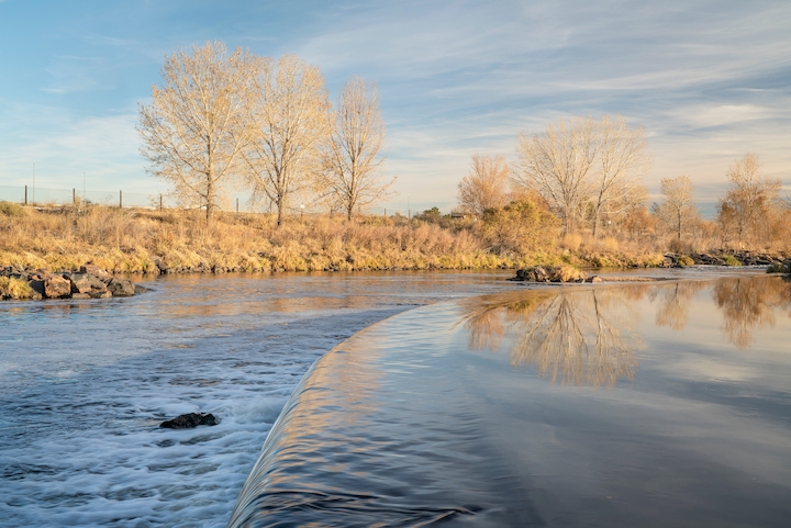
dam on the South Platte River in northern Colorado below Denver, late fall scenery
Why don’t we just use the water from the South Platte? The reason is that 80% of Colorado’s population lives east of the Continental Divide while 80% of the state’s natural water supply flows west of the divide. Add to that the needs of Colorado’s thirsty Eastern Plains farms, and you have a mismatch between the location of water demand and the location of most of the water supply. The South Platte River just isn’t big enough.
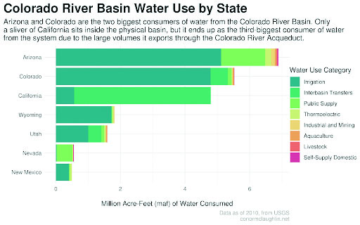
This is a scenario that plays out in similar ways along the entire length of the Colorado River into northern Mexico. Along the river’s course, there are no large cities on or near its banks. The cities, Indian tribes, desert farms, and golf courses that depend on the river’s waters are scattered throughout this sparse land from the Pacific Coast to the High Plains. Forty million people use Colorado River water, most of them residing in cities far too large for their arid environments. And while the South Platte River isn’t big enough to meet the demand of the Front Range, the larger Colorado River is no longer big enough to meet the water demands of all seven states in its basin plus northern Mexico.
Mighty demand on the mighty Colorado
We think of the Colorado River as one of North America’s largest, and in terms of the geographic size of its basin, that’s true. It drains a vast area from northern Wyoming south to Mexico and from eastern California west to a thousand-plus-mile stretch of the Rocky Mountains. But in terms of water volume or discharge, the Colorado River is surprisingly small.
Thirty-six rivers in the United States carry more natural water than the Colorado River. The Mississippi carries 27 times the amount. The Columbia River in the Pacific Northwest is about 13 times larger by volume. The Yukon? Ten times larger. Even the lowly Mobile River, which is only 72 miles long, carries three times the amount of water compared to the Colorado River. We are expecting a lot from a river that is far smaller by volume than most of us realize and highly susceptible to climate changes, natural and man-made alike.
Human-caused climate change is widely believed to be a contributing factor to the current stress on the Colorado River Basin, but it is only one of many compounding variables. This is a land where even natural climate change is believed by many experts to be the primary cause of the rise and fall of whole civilizations. The climate and geological record show that megadroughts lasting several decades or more are normal here. The current megadrought is about 23 years running and coincides with significant population growth in the Southwest. It’s possible that it may turn around soon. We can hope that the big winter of 2023 — and thankfully another healthy snow year in 2024 — represents the beginning of a turning point into a wetter trend. If that happens, we will have gotten very lucky. Or it may just be a blip in a drought that has another century or more to go, for even megadroughts have wet years within them. Nobody knows which way it will go. Therefore, we must adapt and plan for the worst-case scenario.
 Studying the ancient human artifacts and geologic strata of the area can unlock secrets of the past that can help us plan for the future. According to the book “Where the Water Goes” by David Owen, around the year 600 A.D., the Hohokam people “built and maintained what was then one of the world’s largest and most advanced irrigation systems in what’s now southern Arizona.”
This ancient agricultural society “diverted water from two Colorado River tributaries, the Gila and the Salt, and fed it into extensive networks of canals and ditches, with which they irrigated tens of thousands of acres of agricultural land roughly where metropolitan Phoenix is today,” wrote Owen. “Then, around 1450, the Hohokam and their complex agricultural society disappeared.” No one knows definitively why the society vanished, but one theory is that the cumulative effects of irrigation on the soil caused massive crop failures because of dissolved salts that leached into the soil and groundwater over the centuries, ultimately killing the harvest.
If that’s the correct theory, it demonstrates the importance of adaptation to changing conditions, which is exactly the kind of thing we are facing now in the same region. And, again, the needed adaptation likely must look to agriculture as the single most important contributing factor. The urban demand for the Colorado River’s water is dwarfed by the agricultural production of the area. California’s Imperial Valley sees less than three inches of annual rainfall, and yet it is an enormous producer of year-round produce, including 85% of America’s winter harvest from leafy greens to citrus fruits. The Imperial Valley alone receives an annual allotment of 3.8 million acre-feet of water from the river, which is about what the entire state of Colorado receives and a full 1.5 million acre-feet more than the entire state of Arizona.
Despite popular belief and convenient assumptions due to its proximity to Lake Mead, Las Vegas is only a minor contributor to the pressure on the Colorado River Basin. In fact, Las Vegas represents an exemplary example of urban water management headed in the right direction. Three quarters of a million more people live in the Las Vegas area now compared to just 20 years ago, but during that same period, the city has managed to reduce its water consumption by a staggering 30% or more, mostly through practical laws and incentives.
As admirable as Las Vegas’ water policies have been, the reality is that urban water management, no matter how successful, can only make a small dent in the problem. Desert golf courses and casino fountains make for easy scapegoats, but it is irrigation-based agriculture that is by far the largest draw of Colorado River water. Food production along with the multi-decade megadrought is why Lake Mead is falling and threatening to reach the dreaded dead pool level.
 Who owns the water?
Water rights law is extremely complicated, and in the West, it can seem to make little sense in some cases. Unlike most of the world, even in the eastern United States, western water rights are based on the principle of “prior appropriation.” In layperson’s terms, this means that the first person to use the water has first rights to the amount of water they use regardless of where they are.
In the Colorado River Basin, the “law of the river,” as they say, was established over 100 years ago in the Colorado River Compact. This legal agreement divides the seven states in the basin into two halves, the upper basin and the lower basin. Colorado, Wyoming, Utah, and New Mexico are in the upper basin. California, Arizona, and Nevada make up the lower basin. One of the long-standing issues is that most of the water comes from the upper basin, but most of the consumption demand is in the lower basin, and this misalignment is getting bigger. The Colorado River also flows into northern Mexico before its mouth at the Gulf of California, so Mexico also has a small portion of the water rights. The Colorado River Compact gives each basin 50% of the U.S. rights to the water, but the upper basin states have never used their full legal allotment, even in the driest of years.
How can it be that the upper basin never uses its full legal allotment, and yet all the water in the river is used before it reaches the sea? The reason is called “paper water.” When the Colorado River Compact was written, it was based on years of historically higher than average flows in the early 1900s. Because of this, the total legal distribution of the river’s water is more than the real water that flows in the basin today. In short, the water is over-allocated.
The result is diminishing water levels in Lakes Mead and Powell as the “bank” of saved water in the reservoirs is depleted more than snowmelt each spring can replace. This also results in a river that is used up completely before it reaches the sea, creating an ecological chain reaction in Mexico and the Gulf of California as a once vast wetland delta has literally turned to dust.
Despite the difficult circumstances, there are reasons to be hopeful that the Colorado River water crisis can be mitigated to avoid a disaster, even if the megadrought persists and snowbirds keep moving to the desert to play golf. Doing so will require seven states and the federal government, specifically the Bureau of Reclamation within the Department of the Interior, to work together. In today’s political environment that might seem challenging, but the process is already moving. The Inflation Reduction Act and the Bi-Partisan Infrastructure Bill include a combined $14.5 billion to “enhance the West’s resilience to drought, the largest investment in climate resilience in our nation’s history.” That money will be supplemented by state-level investments from the seven basin states.
Another positive is that, ultimately, the federal government has the final authority. States’s rights advocates may not like the sound of that, but river systems cross state and national boundaries and a central point of authority is a necessity when it comes to interstate commerce and resources, especially one as critical as this.
Long-term initiatives from 2027 onward are yet to be confirmed, but in general, there are supply-side and demand-side opportunities that likely need to be pursued together. Supply management is about increasing the amount of water available to meet growing demand. Demand management is about using that water more efficiently to reduce consumption. In both cases, there are many things that can be done with a combination of infrastructure investment, education, a focus on more sustainable practices, and political will. This must all be achieved while simultaneously limiting the impact on the ecosystems within the basin and, hopefully, restoring past damage.
After decades of little to no Colorado River water reaching the ocean, a “pulse” of 100 thousand acre-feet of water was released from the last impoundment in Mexico in 2014. For nearly two months the river flowed once again all the way to the Gulf of California, and the dry delta immediately sprang to life with greenery as astounded ecologists measured the resiliency of nature.

Lake Mead National Recreation Area – Low Water Level on Colorado River Reservoir Shoreline – Drought, Water Rights
Lake Mead may never again reach full pool unless there is a major decades-long shift to a wetter climate, but it does not ever have to reach dead pool either, even if the megadrought continues. There are many things that can and likely will be done in the years to come to ensure the lasting health of the Colorado River system and the well-being of all that depend on it.
The example set by the city of Las Vegas gives us hope that it is possible to achieve similar results on a much larger scale. Agriculture can be made much more efficient through incentivizing the planting of less thirsty crops. Untapped water tables can be utilized in places to relieve pressure on the comparatively little surface water. New technologies can be deployed to reduce waste and improve efficiency.
Regardless of the specific solutions, changes must be made for a sustainable Colorado River Basin, and some of those changes might impact us right here in the Front Range as the first consumers of Colorado River water. The alternative of dead pool is not an option.